QUINCY LIBRARY GROUP
P.O. Box 1749, Quincy CA 95971
August 11, 2000
USDA Forest Service CAET
Sierra Nevada Framework Project
P.O. Box 7669
Missoula, MT 59807
Dear Content Analysis Enterprise Team and Regional Forester Powell:
These are the Quincy Library Group (QLG) comments and recommendations regarding the Sierra Nevada Forest Plan Amendment Draft Environmental Impact Statement (SNFPA DEIS). Roughly a dozen members of the Quincy Library Group have actively participated in many public meetings, workshops, and comment opportunities related to the Sierra Nevada Conservation Framework Project since its inception in 1998. We submitted extensive letters of comment in August and October 1998, prior to the scoping period for the SNFPA EIS. In those communications and in lengthy scoping comments in January 1999, the QLG has done its utmost to provide thoughtful, well researched, and fully documented discussions of major management issues facing the Forest Service in the Sierra Nevada's national forests. We have attended all of the regional and statewide public meetings and issues workshops in attempts to better understand and participate in the Framework process. We have reviewed and discussed among ourselves the SNFPA DEIS.
Summary of QLG Recommendations
After all our efforts in the Framework's meetings, workshops, and various other processes, QLG members are disappointed to find that none of the SNFPA alternatives adequately addresses critical management issues involving fire, fuels, wildlife, watershed maintenance and water yield, or economic impacts of the contemplated management regimes. The Quincy Library Group believes that the Herger-Feinstein Quincy Library Group (HFQLG) Pilot Project does address those management issues in a coherent and achievable structure of true adaptive management. The HFQLG Pilot Project would not only provide the demonstration of effectiveness specified in the Herger-Feinstein Quincy Library Group Forest Recovery Act (HFQLG Act, or the Act), but would also be a demonstration of very great value to the entire Sierra Nevada and other inland western forests. Therefore we recommend that:
1. The HFQLG Pilot Project should be designated by the Sierra Nevada Forest Plan Amendment (SNFPA) Record of Decision as a concurrent Region 5 Pilot Project to demonstrate one potential for addressing the issues raised in the SNFPA Draft Environmental Impact Statement (DEIS).
2. The SNFPA Decision should specify California Spotted Owl Guidelines for the Pilot Project that would permit and facilitate full implementation in a cost-effective manner of the Pilot Project, as required by the HFQLG Act. Such guidelines would be effective in the HFQLG area during the term of the Pilot Project, and apply to HFQLG projects initiated during the Pilot Project until their completion.
3. At the end of the Pilot Project, the HFQLG area (most of the Lassen and Plumas National Forests, and the Sierraville Ranger District of the Tahoe National Forest) would revert to whatever guidelines are specified for general use in Sierra Nevada national forests and/or guidelines that are specified in the Land and Resource Management Plan (LRMP) amendments or revisions that are required by the Act.
4. The alternative adopted for the remainder of the SNFPA area, which would also have effect on the HFQLG area after the Pilot Project is finished, and be subject to modification by the LRMP amendments referenced above, should be based upon and implement the following elements:
a. Pay greater attention to the problems identified in the United States General Accounting Office (GAO) Report Western National Forests: A Cohesive Strategy is Needed to Address Catastrophic Wildfire Threats, Report No. GAO/RCED-99-65, April 1999 (copy attached) and give very high priority to full implementation of the “Cohesive Strategy” that was recently announced by the USDA Forest Service Washington Office response to the GAO report in the paper Protecting People and Sustaining Resources in Fire-Adapted Ecosystems - A Cohesive Strategy (copy attached). The scale and pace of fuel reduction in the Sierra Nevada should be increased to match the scale and pace specified by that Cohesive Strategy.
b. Facilitate silvicultural management that can correct unsustainable forest structures and species compositions which have come about in tandem with the increase of fuels and contribute to both the fuel problem and other forest health problems.
c. Reconsider the benefits of fuel reduction and the adverse effects of not reducing fuel. Fire effects should be projected according to the trend line of recent fire history, which the DEIS shows to have averaged about 76,000 acres burned per year for the last ten years, rising 3,700 acres per year. These effects should be disclosed for the whole analysis period (assumed to be at least 50 years), not just the first decade projection based on a much lower average, which is now displayed in the DEIS.
d. Assumptions and conclusions about the effects of management on spotted owl viability must be brought into line with what the science can actually demonstrate are cause-and-effect relationships. The conclusions now in the DEIS regarding the supposed effects of management activity on owl habitat, and in turn the linkage of those effects to species viability, are not supported by valid scientific data or analysis.
e. On the basis of the above re-analysis of fire effects and the effects of management activity on spotted owl viability, revise the estimated balance points among potential benefits and adverse effects, between taking action and taking no action. Reconsider other effects of limiting fuel reduction and other management activity because of uncertainty regarding spotted owl viability. What are the potential losses of life and property? Of watershed function, wildlife habitat, and all other forest-based benefits? What are the benefits to both human and wildlife populations of fuel reduction and other active management efforts to restore appropriate forest structures and maintain forest health? All empirical and logical evidence points to far greater potential habitat losses due to catastrophic wildfires than to the effects of management activities such as thinnings and fuels reductions.
f. Pay greater attention to both the need and the opportunities for reinvestment in watershed maintenance and improvement by the major downstream uses of the water produced on Forest Service land.
g. Provide flexibility at the Forest and Ranger District level to design appropriate management responses to local and sub-regional landscapes, situations, and opportunities.
h. Continue to protect spotted owl Protected Activity Centers (PACs) by rules stated in the California Spotted Owl Sierran Province Interim Guidelines (CASPO) until such time as a complete scientific analysis clearly indicates a need to remove or modify those protections. There is nothing in the public record for the Framework which indicates that current management direction for PACs, when implemented faithfully, fails to provide suitable nesting and roosting habitat for spotted owls.
i. There must be less dependence on prescribed fire for routine forest fuel reduction.
j. Greater consideration must be given to the need for sustaining the community and industrial infrastructure that is required to perform the increased scale and pace of fuel reduction that is specified by the Cohesive Strategy, and to conduct other essential forest health restoration efforts and management activities authorized by law.
Which Alternative?
QLG believes that none of the alternatives in the DEIS would actually implement the scale and pace of fuel reduction that is required by the Cohesive Strategy and is recommended by QLG. It does appear, however, that Alternative 4, with sufficient adjustment, would come closest to implementing the Cohesive Strategy and would provide the best opportunity to achieve the other long term management objectives outlined above. The specific adjustments we recommend for Alternative 4 are listed in the final Recommended Alternative section of these comments.
An expanded discussion of the above elements and recommendations is provided below.
Relationship of the HFQLG Pilot Project to the Sierra Nevada Forest Plan Amendments
By means of the HFQLG Act, Congress established a Pilot Project to demonstrate the effectiveness of specified management activities that together comprise a coordinated strategy for addressing core issues of national forest management in the QLG Area. These same issues are central to the SNFPA DEIS: catastrophic fire; silviculture and forest structure; wildlife; watershed and riparian function; designation of reserve areas; and how the management responses to these issues generate social and economic costs and/or benefits to human populations.
On each of these core issues the SNFPA DEIS and referenced literature reveal different views among scientists and interested parties on how land and resource management should proceed. The range of these views is wide, but a regional decision must be reached. Two approaches are possible: (1) try to average up all the scientific opinions and public demands, then implement one set of standards, guidelines, and processes across the Sierra Nevada in one master plan; or (2) permit and facilitate the development of several plans, each one representing a strategy that is within the range of responsible scientific and public opinion, is feasible to implement in the sub-regional area it is intended for, and is designed to include a strong component of monitoring and evaluation that would refine or correct the initial assumptions and support true adaptive management.
QLG strongly recommends the second approach, because the Sierra Nevada is inherently too varied a landscape and ecosystem for one set of guidelines or one master plan to be workable. Even if a master plan were possible in theory, there isn't enough scientific knowledge to permit the safe construction of such a plan in practice. That is, we simply don't know enough about these forest ecosystems to justify putting all our spotted owl eggs in one basket.
QLG recommends adoption of the HFQLG Pilot Project as one sub-regional strategy, because the HFQLG Act deals with the major issues of the DEIS, and this Pilot Project already has a completed EIS that provides the scientific, management, social, and economic basis for its immediate implementation. Wherever an SNFPA issue is not specifically dealt with in the HFQLG Act, for example noxious weeds, the corresponding provisions of the basic SNFPA EIS could be implemented in parallel with the Pilot Project consistent with full implementation of the HFQLG Pilot Project. National Environmental Policy Act (NEPA) processes are available to avoid or mitigate effects in situations where genuine resource management conflicts arise.
The HFQLG Pilot Project deals with the major DEIS issues as described below.
Fire hazard and fuel reduction strategy. The Pilot Project calls for a five year program of defensible fuelbreak construction (Defensible Fuels Profile Zones, or DFPZs), which would reduce forest fuels by mechanical thinning, and prescribed fire where appropriate, around communities and along existing roads, to provide safe and effective defense lines for fire fighting operations and to make wildfire less likely to spread from the forest into communities, from communities into the forest, or across large areas of forest. The five year HFQLG program is intended to be a first step based on DFPZs, to be followed by continuing area treatments at equivalent pace, until a satisfactory long term fuel regime is established and can be maintained across the whole forest, so that designated fuelbreaks are no longer needed.
The DFPZ strategy would also establish a base from which to extend the fuelbreak network onto adjoining private property, and it would facilitate cooperative projects for fuel reduction and fire protection with industrial and non-industrial property owners, and with County Fire Safe Councils under the California Department of Forestry and Fire Protection “California Fire Plan.”
We are concerned to note that the DEIS fails to designate any “urban interface” zones in the QLG area for years after Year Five when the Pilot Project terminates. Most of the DEIS alternatives will focus National Forest fuels reduction and fire safety efforts on desginated urban interface zones. Since the QLG-area National Forests have none designated, it would appear from the DEIS that the Framework would virtually end forest fuels management in rural and wildland areas of the beginning in Year Six of implementation. Only the HFQLG Act seems to have caused the Framework alternatives to have any pre-suppression fuels management occur in rural and wildland areas in the first five years of the plan. The Forest Service's statutory missions to protect watersheds, wildlife, and to provide sustainable flows of goods and services do not apply just in the urban-wildland interface, but across all National Forest System lands. On a more personal and visceral level, we who live responsibly in rural communities and rural areas feel we deserve no less protection from wildfire than residents of more densely populated areas.
We believe that the HFQLG strategy of DFPZs followed by area treatments is superior to the Strategically Placed Area Treatment (SPLAT) strategy described in the DEIS, because: (1) DFPZs would interrupt the continuity of fuels at landscape scale around communities and across the whole forest, whereas the SPLAT strategy would largely treat disconnected areas, with only a few DFPZs around major communities; (2) DFPZs would provide quick access to prepared defense lines across the whole forest for effective fire suppression operations and safe retreat if necessary, whereas the disconnected SPLATs would not usually be accessible by fire-safe roadways and would not provide continuous prepared defense lines or safe escape routes; and (3) the DFPZ strategy would have greater beneficial effect earlier than would SPLATs, because DFPZs effectively interrupt horizontal continuity of fuel at landscape scale within the first five years of the HFQLG strategy, whereas the moderation effects on large fires that are claimed for SPLATs depend on first achieving fuel reduction on areas amounting to 30 percent or more of the landscape, which would take 20 years or more at the rates contemplated in the DEIS.
The key necessity in either strategy is actually to accomplish fuel reduction at adequate scale and pace. The Pilot Project requires a scale and pace that is very much in line with the scale and pace of treatment specified in the recently released USFS Washington Office report, Protecting People and Sustaining Resources in Fire-Adapted Ecosystems -- A Cohesive Strategy. In contrast, the SNFPA DEIS proposes a scale and pace of fuel reduction that are at best about half that required by the HFQLG Act or the Cohesive Strategy, and for some alternatives the shortfall is even greater.
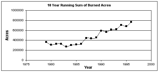
In our view one reason SNFPA calls for too little fuel reduction and too slow a pace is because the fire effects analysis in the DEIS is illogically based on a level projection into the future of the average acres burned during the last 27 years. This is not a reasonable assumption, given the clear trend shown by the graph of recent fire history, DEIS Figure 3.5h, page 3-163, reproduced below.
Each point on the graph represents the acres burned during the indicated year plus all the acres burned in the nine years previous to the indicated year. For example, the lowest point on the graph is for the decade ending in 1983, which shows a total of about 280,000 acres burned in the ten years from 1974 through 1983, or a yearly average of 28,000 acres. If you draw a straight line that best represents the points from 1983 through 1996, it shows a remarkably steady increase in average acres burned, from the low of 28,000 to a high of 76,000 acres per year, which represents an average increase of 3,700 acres per year.
In spite of this clearly rising trend, the DEIS conclusions are based on an assumption that the overall average of about 47,000 acres per year would become the average burn from the year 2000 all the way to the year 2050. We believe that assumption is not reasonable, and has led to equally faulty assumptions about potential loss of habitat and other forest values due to wildfire in the DEIS evaluation and comparison of the alternatives.
In response to questions raised by QLG and many other interested parties, the SNFPA Inter-Disciplinary Team (ID Team) has indicated it will re-run the fire effects and habitat models on the assumption that a more recent average burn of about 72,500 acres per year will continue unchanged into the future. QLG does not believe that a flat rate of either 47,000 or 72,500 acres per year is a reasonable assumption to make, because neither rate takes account of the most significant fact displayed by the graph, which is that for a significant period of recent history there has been a persistent increase in acres burned.
These points are best illustrated by adding lines to the graph, as shown below, which project the three assumptions: A = response of the 10-year sum if 47,000 acres per year starts in the year 2000 and continues; B = response of the 10-year sum if 72,500 acres per year starts in the year 2000 and continues; and C = continued rise at the recent historic rate of 3,700 acres per year. Is there anything in the fire experience of this year and the last few years to suggest that the upward trend of the graph has leveled off, much less turned downward? Which of the three lines seems the most logical assumption to make regarding acres of wildfire to prepare for in the future?
[ Insert graphic: approximation of DEIS Figure 3.5h, with three projections to the year 2025:
A = DEIS assumption of about 47,000 acres per year;
B = “Corrected” Forest Service assumption of about 72,000 acres per year;
C = the obvious trend continued. ]
Failure of the Final EIS to base its fire effects analysis on a realistic projection of acreage burned in wildfire is a violation of both NEPA and National Forest Management Act requirements to base decisions on the best available data: see, for example, 36 CFR 219.12(d); 40 CFR 1500.1(b); and 40 CFR 1502.24.
Silviculture and forest structure. Forest Service specialists in the QLG area have described three zones that characterize the local forest structure: mixed conifer with relatively high annual precipitation in the west; mixed conifer and pine with less precipitation in a transition zone starting just east of the main mountain ridge; and eastside pine with little precipitation in the east. Due to fire suppression and other historic management practices, these forests are now quite different from their original species composition and structure. The mixed conifer to the west has lost much of its original pine component, and is now generally dominated by white fir. The transition zone has also lost much of its original dominance by pine, with white fir and incense cedar encroaching upon or replacing pine at mid elevations, and a few largely unaffected red fir stands at high elevations. The eastside is still heavy to pine, but there is a significant encroachment by white fir that is not well adapted to the east side soils and climate.
The ages and structures of these forests at low and middle elevations have also changed, from the original stands dominated by relatively few trees of relatively large size, to today's stands that have few large trees, an over-representation of middle size trees, and hundreds of very small trees per acre.
The proliferation and encroachment of white fir contributes heavily to an extreme fire hazard for two main reasons: (1) the hundreds of small trees per acre make a highly combustible fuel bed and fire ladder; and (2) where white fir is overcrowded or has invaded the drier pine stands, it is overly susceptible to disease and drought, and the dead trees become an additional fire hazard.
The answer to this problem isn't just to remove the encroaching fir trees. These forests must be managed in a way that will also regenerate the pines. Since pines are much less tolerant of shade than firs and cedars, the regeneration of pines depends on creating openings in the forest that will give them enough sunlight. The HFQLG Pilot Project calls for creating small openings by a silvicultural method called “group selection,” which would re-establish the patchy structure of the original forest and permit pines to regain their natural place and function in these forest landscapes. The SNFPA DEIS alternatives fail to address tree species management, the restoration of sustainable species mixes, and the regeneration of under-represented species. These and other problems concerning sustainability, native biodiversity, and sustained yield timber management are required to be addressed through forest planning processes pursuant to the Forest and Rangeland Renewable Resources Planning Act of 1974 and the National Forest Management Act of 1976. The forest planning regulations at 36 CFR Part 219, particularly sections 219.10 through 219.27, have not been satisfied by the SNFPA DEIS.
The California spotted owl and other wildlife. A major issue in the DEIS is how to manage the forests for long term viability of the California spotted owl. Other focal species and wildlife in general must also be provided for.
Regarding wildlife in general, the DEIS shows the projected effects on habitat for 270 species in a series of graphs on pages 3-259 to 3-264, with more detailed analysis on pages 3-266 and 3-267. The obvious conclusion from these graphs and the accompanying explanations is that there is no significant difference among the alternatives on this issue. If the titles were removed, we don't see how even an expert could tell which graph belonged to which alternative. Even when the comparisons were limited to the thirty species that exhibited the greatest sensitivity to differences among the alternatives (Table 4.B.2, pg 3-265), it is hard to see significant differences from alternative to alternative for most of these species, with the possible exception of Alternative 4, which consistently shows an advantage, because less habitat is lost over 50 years, compared to the other alternatives.
Since wildlife habitat in general is apparently not very sensitive to choice of alternative, the wildlife habitat issue hinges largely on the focal species dealt with in section 4.3, mainly the California spotted owl. The questions of significance regarding the owl are: (1) Is the reproduction rate adequate to sustain the owl population? and (2) If the reproduction rate is not adequate, is it lack of suitable habitat or something else that causes the problem? According to the DEIS (pg 3-341), “The question of whether forest management is a primary factor in recent observed declines in California spotted owls remains unanswered, but a direct causal link seems unlikely” [emphasis added]. And further, “...it is not possible to determine if changes in the distribution and amount of habitat are responsible for changes in owl distribution and abundance.” Nevertheless, in spite of these flat denials that a cause-and-effect relationship can be established, the very next paragraph of the DEIS says that “Current concerns regarding California spotted owl population trends are related to the effects of vegetation management on the distribution and abundance of habitat elements that are deemed important to the ecological requirements of spotted owls.” [emphasis added]. In other words, an assumption is made, but nothing can be demonstrated or shown, much less proved, in support of that assumption. QLG does not accept that it is sufficient to “deem” (i.e. decide on the basis of opinion) that increasing the amount of “suitable owl habitat” as currently defined, is the key element in assuring owl population viability.
The title of DEIS Section 4.3.1, California Spotted Owl is coupled with a reference “Abstracted from Lee and others 2000.” A QLG member well versed in spotted owl issues conferred at length with Lee, obtained copies of the referenced papers, and has searched them diligently for data that would support the assumption that “suitable owl habitat,” as usually defined in the DEIS, is the key factor in spotted owl viability. As noted earlier, the DEIS clearly says that no cause-and-effect relationship can be established, and this conclusion was confirmed by QLG examination of the approximately 1,500 pages of owl-related documents that are referred to in the DEIS.
But the QLG review of these documents indicates more than that. Current and recent scientific studies show differences among the owl experts' views, which are not revealed in the DEIS to the public and which are not reflected in the proposed management alternatives and strategies. One of the greatest disagreements is over the proper interpretation of the estimate of lambda, the annual population trend, and its accuracy. One large factor for the researchers' doubt of their own numbers is that their own field studies show California spotted owls exist at higher densities than their lambda calculations would imply. There are several significant error and assumption factors in the lambda model equation. There is general agreement that spotted owls are declining from 1992 levels, but different studies detect different rates of change. The DEIS fails to disclose and discuss the implications of the different interpretations upon the management strategy and direction of the DEIS alternatives.
California spotted owl researchers are fundamentally unsure about the natural population fluctuations of the California spotted owl. Some life attributes (a long life span, delayed onset of breeding, low rates of reproduction, and irregular reproductive attempts) indicate that California spotted owls may be a species whose long-term survival strategy is to opportunistically increase and decrease in abundance according to habitat quality and climate patterns. Both climate and habitat quality have now been shown to be factors that affect annual reproductive success rates, but not in the ways addressed in the DEIS and its related planning papers.
Climate appears to operate at two habitat scales in affecting California spotted owl reproductive rates. Research by Malcolm North and others at the Forest Service's Pacific Southwest Forest and Range Experiment Station in Fresno has correlated cold spring storms (such as are common in the Sierra Nevada in El Nino/La Nina climate cycles) and nest tree overcanopy structure with nesting failures by spotted owls. While the weather patterns are obviously beyond the short-term control of the U.S. Forest Service, the protection and conservation of nest stands is within management control. However, the SNFPA DEIS applies the wrong scale to the problem in all alternatives: it is not a landscape or watershed-level management need, but rather a nest stand-level need. This management need is applicable at the scale of the 300-acre Protected Activity Centers (PACs) and Spotted Owl Habitat Area (SOHA) 300-acre core and replacement core habitat designations, which already perform the management function in the CASPO Interim Guidelines. The SNFPA DEIS appears to apply nest stand-level and tree-level to the entire landscape, without regard for other studies showing the need for other habitat requirements and without due consideration to Sierran fire ecologies.
Research conducted during the 1990s on both northern and California spotted owl subspecies leads several leading researchers to conclude that mature and old-growth forest types do not define suitable owl habitat. There appears to be an ecological trade-off between the higher adult survival rate of interior old growth forest habitat and the higher reproductive rate associated with some amount of fragmentation and edge habitat. Some degree of patchiness in forest structure appears to enhance spotted owl reproductive rates by boosting prey populations.However, nearly all researchers have expressed an inability to study the overall habitat/reproduction rate linkages due to inaccurate, outdated vegetation inventories. Key management questions cannot be resolved until current, accurate inventory information is utilized in both research and planning. Knowing its critical importance in forest management planning, the Framework failed to meet scientific integrity standards (40 CFR 1502.24) and best available data standards (36 CFR 219.12(d) when the ID Team assumed the FIA vegetation data set was accurate enough.
If any conclusions could legitimately be drawn from this material they are probably more along these lines: (1) The number of eggs laid (i.e. the number of females who successfully breed and the number of eggs each one lays) seems to be closely related to the abundance of prey in that year and the preceding year (the second, more hypothetical climate effect), which largely determines whether or not owls come into breeding condition at all. (2) While several kinds of nest sites are readily used by owls, survival of the chicks always depends on whether there is enough food, and often depends on whether there is enough cover over the nest to protect young chicks from cold spring rain and snow storms that may occur. (3) The weather-related chick mortality seems to relate to nest tree and local stand structure, not to the kinds and amounts of habitat in the remainder of owl territories. (4) The demographic models on which the DEIS depends all fail to account for floaters and outmigrant owls, and this skews the data on which the DEIS is based toward finding a lower survival rate than actually exists. (5) Existing research on spotted owls ignores adverse effects on owl habitats and populations due to wildfire.
Based on those factors, we believe that both the available data and common sense indicate that: (1) the DEIS is mistaken to require nest tree and local nesting stand attributes to be applied to very much larger areas of habitat; (2) the suitability of a nest site depends mostly on the primary canopy layer above the nest, without critical dependence on multiple layers underneath; (3) the most critical factors are a dense canopy right at and over the nest site and an adequate prey base; and (4) the primary owl diet, whether wood rats at lower elevations or flying squirrels at higher elevations, is likely to be more abundant and available in forest structures that are patchy, edgy, and generally more open than the dense stand conditions that are emphasized in the DEIS.
Studies that purport to define “suitable habitat,” and show that owls “need” it, are generally based on statistical analysis of the movements of radio-tagged owls, from which the “preferred” forest structures are determined (i.e. where they spend most of their time). We believe this method depends too much on determining “preferences” and gives too little attention to “necessities.” Owl literature describes successful nesting in a wide variety of places that do not fit the DEIS definitions of “suitable nesting habitat.” Preferable habitat would be nice to have, but an adequate food supply is absolutely necessary. In these matters, we suspect that owl parents are not much different from human parents. We'd all like to raise our kids in fine houses if we had the choice, but we know they'll do better being well fed in a shack than going hungry in a penthouse.
Unfortunately, there has seldom if ever been an attempt to define “suitable prey habitat” in terms of how much owl food such habitat is able to support and how much the prey population varies over time. The SNFPA DEIS and all owl analyses need more emphasis on prey ecologies and the management of habitat according to prey needs and preferences, not just owl preferences.
Watershed and riparian function. Two systems are used in the DEIS to define the widths of riparian buffers:
The so-called “variable width” system of buffers applied to Alternatives 2 through 5 defines an inner “green” zone (modeled as 150 ft wide from each stream bank or equivalent edge of other body of water), and an outer “gray” zone (extending an average of about 500 ft from the stream bank or equivalent edge). The gray zone width modeled for the DEIS would vary with the slope, ranging from about 425 ft where the slope perpendicular to the stream is shallow, to about 800 ft where the slope is steep. These green and gray zones extend full width all the way upstream to the upper ends of ephemeral channels, where “...evidence of annual scour and fill” can be found. Watershed analysis of cumulative watershed effects would be required before conducting management activities in these zones. Management activity would be limited by a modified Equivalent Roaded Acres (ERA) method, computed as specified in the Sierra Nevada Ecosystem Project (SNEP) Report, Addendum Chapter 2, with cumulative ERA limits of 5% in green areas, 10% in gray areas, and 15% on whatever “upland area” is left outside the gray.
The other system in the DEIS defines “flexible width” buffers, applied to Alternatives 6 through 8, of 300 ft each side of perennial streams, 150 ft for intermittent streams, and 75 ft for ephemerals, with the upper ends of ephemerals found by the same “annual scour and fill” standard as applies to the green-gray system. Watershed analysis of cumulative effects would be required
The HFQLG Act requires the use of riparian buffers for the Pilot Project that are defined by the Scientific Analysis Team (SAT) Guidelines. Under SAT guidelines minimum widths are measured from the edge of a stream, lake, pond, or wetland, and they must include areas that extend to the top of an inner gorge, the outer edge of the 100-year flood plain or the extent of seasonally saturated soil, the outer edge of riparian vegetation, and to the extent of landslides or landslide-prone areas, whichever distance is greatest. The minimum width is 300 ft each side of a fish-bearing stream or from the shore of a lake, 150 ft each side of a permanently flowing non-fish-bearing stream, or the side of a pond, reservoir, or wetland greater than one acre, and one site-potential tree height (100 ft minimum, in most places about 150 ft) each side of an intermittent stream. Activities within the SAT buffers are limited to those shown by watershed analysis to promote riparian and/or aquatic functions, rather than being determined by Cumulative Watershed Effects Analysis (CWEA) thresholds.
QLG believes the SAT definitions are marginally superior to the so-called “flexible width” system, because SAT takes better account of actual riparian characteristics, such as the width of a gorge or the extent of a flood plain, saturated soil, riparian vegetation, and unstable soils in slide-prone areas. We are sure that either the SAT or the flexible system would be greatly superior to the so-called “variable” (green-gray) system, because at bottom the green-gray system is arbitrary and illogical, as explained in the attached QLG letter of March 4, 1999, addressed to the SNFPA ID Team leader.
The major deficiency of the green-gray system is that it defines very wide buffers very far upstream, so that in many watersheds virtually the entire landscape would be subject to “riparian area” restrictions, seriously interfering with Forest Service capability to reduce fuel and regenerate sustainable forest structures, or to provide access for other activities of value to the public.
Our earlier objections to the green-gray system are still valid, because the DEIS fails to correct errors in the SNEP discussion, but instead just refers readers to SNEP Addendum Chapter 2. That document in turn refers readers to other sources that contain serious errors and/or illogical concepts that to the best of our knowledge the authors have never corrected.
First the method of computing the gray area width is arbitrary, illogical, and contains mathematical errors. Two examples:
(1) The DEIS says to use the “weighted slope” in computing the gray area width. If you compute the slope by the method specified in SNEP, the result will be in error by a factor of three. For example, if the actual slope happened to be a constant 10 percent for five hundred feet, the average slope, whether weighted or not, should still be 10 percent. However, if you apply the SNEP method to compute that average, it would turn out to be 30 percent. Over a year ago QLG submitted a complete numerical and graphical analysis of this error to Steve Clausen, the EIS ID Team leader (see attached copy of the QLG letter), but the error has never been admitted, much less corrected.
(2) The SNEP source documents actually provide two equations for computing the gray area width, one based on slope only and the other based on both slope and soil detachability (i.e. susceptibility to erosion). The DEIS says the slope-only equation “...is a starting point for layout...” and that [for purposes of the DEIS] “...the width varies only with slope, because soil detachability factors were not available for the entire Sierra Nevada for modeling at this time.” [Appendix I, pg I-2] This clearly implies that the second equation, the one with both slope and soil detachability, should be applied whenever those soil detachability factors are available. Since the DEIS requires watershed analysis, and the implication is that a good watershed analysis would produce and consider those detachability factors, the net effect of the quoted statements would be to encourage, perhaps require the use of the second equation, eventually if not now. The problem with this is that the second equation is even less logical and more subject to error than the first, and produces wider gray zones even when erodability is very low. We will not recapitulate the math here, except to say that by its logic there are cases where a more erodible soil would reduce the width of the riparian buffer zone, compared to a less erodible soil. QLG's letter to the SNFPA EIS Team Leader of March 1999 provides details of this analysis. It is time for the Forest Service to pay attention to these errors, not just blindly parrot SNEP.
A second major deficiency of the green-gray system is that is imposes unwieldy limits on management by means of a modified ERA computation based on -- you guessed it -- SNEP Addendum Chapter 2. Instead of being an improvement, the modified method is in some ways a step backwards. Examples:
(1) The SNEP ERAs are considered in the DEIS not to be “Thresholds of Concern” (TOCs) but presumptive limits until proved otherwise. This changes the ERA concept, which rests on shaky ground to begin with, making it a stop sign instead of an early warning. It would also tend to discourage the planning of projects in the difficult situations where management action is probably most needed. The environmental and public use consequences of discouraging management action in difficult situations are adverse and potentially very damaging.
(2) These presumptive limits are computed separately for the green, gray, and upland zones, and each zone must stay within its own limit. That may seem like a reasonable theory, but in practice it would fragment the watershed analysis and prevent the compensation of difficulties in one area by imposing additional mitigations in a related area. That is, instead of considering watershed function as an integrated whole, the SNEP method of computing ERAs would promote the view that watersheds are composed of three separate zones that have to be analyzed and managed independently.
(3) Perhaps more importantly, the new system perpetuates instead of fixes a serious flaw in the old system, because the ERA coefficients defined in SNEP still differentiate only by broad classes of treatment, and thus fail to give credit for using “gentle” methods in preference to “hard” methods. For example, the ERA coefficients referring to silviculture are based on only three categories of activity: tractor, cable, or helicopter. Therefore no credit is given in the tractor category for using equipment that exerts low ground pressure instead of equipment that exerts higher ground pressure, or for using equipment that can reach out to cut several stems from one location instead of having to move up close to each individual stem.
Finally, the DEIS fails to give the public valid information on which to base a comparison of the green-gray method (Alternatives 2 through 5) against the flexible width method (Alternatives 6 through 8), because different methods were used to identify the affected streams, and significant information on the amount of area affected by the green-gray method was not reported.
Regarding different methods, both the green-gray and the flexible width riparian zones are said to apply to riparian areas with identical definitions -- upstream to the highest point “...where a runoff channel has evidence of annual scour and fill...” Nevertheless, the stream systems actually analyzed for the two systems were significantly different. This is apparent in the text of Appendix I, and it is obvious on the large map titled “Modeling Approaches to Riparian Areas” that was distributed with the DEIS. In the example map from the Sierra National Forest, most of the numerous ephemeral streams shown on the “flexible width” example are completely missing from the “green-gray” example, though both use the same definition of “ephemeral stream” and refer to the same quadrangle map. By using two different representations of the Sierra Nevada riparian system, the DEIS prevents any meaningful comparison of the two methods for determining riparian areas. Failure to provide for meaningful comparisons among alternatives is a violation of 40 CFR 1502.8 and 1502.14.
Then the DEIS makes it even less possible to do a meaningful comparison, by failing to disclose the acreage of gray area produced by the green-gray system. Table 2.5 on page 2-49 says it reports “Acres in Riparian Areas ... by Alternative,” though in fact it reports the entire amount of “flexible” riparian area but only the “green” area of the “green-gray” riparian area. The numbers given by this table to compare the alternatives say that about 1.9 million acres are in riparian areas for Alternatives 2 through 5, and about 2.5 million acres for Alternatives 6 through 8. This summary strongly implies that Alternatives 6 through 8 would put about 30 percent more acreage into riparian areas than Alternatives 2 through 5, but this is a completely false basis for comparison, because it omits any mention of the gray areas. Since the gray acreage is not reported anywhere in the DEIS, we have to estimate it ourselves for comparison purposes. Judging by the large example map and Table I-1 (Appendix I page 3), the average width of the gray area is certainly more than 450 ft and probably close to 500 ft -- call it 480 ft from each stream bank. The green zone is said to extend a constant 150 ft from each stream bank. Thus there would be 330 units (480 minus150) of gray-only for every 150 units of green. That would make nearly 4.2 million acres of gray, for a total of about 6.1 million acres in riparian buffer zones -- over half of the total Sierra Nevada landscape. We believe the limits imposed and the analysis required on this huge area would cause serious adverse impacts on Forest Service ability to implement fuel reduction and other forest health improvements of adequate scale, and to implement them within a reasonable time and cost.
In case our method of calculating the gray area is challenged, we offer an alternative way to look at it. You could assume that the riparian system base maps that were used for computing the “flexible” riparian areas are more accurate than the maps used for the green-gray computations. In that case a reasonable estimate for that the average width of the “flexible” areas is somewhat less than 150 ft from each stream bank, because the intermittents are 150 ft and there are many more ephemerals at 75 ft than perennials at 300 ft. Therefore the equivalent “green” area would be somewhat more than 2.5 million acres on that version of the riparian system map, and the gray areas would be a somewhat higher proportion of the total, so a reasonable estimate of the total green-gray system using the other base map would be closer to 8.5 million acres.
To sum up these points, the EIS Team can't have it both ways. Either the gray areas are significant and must be disclosed and their effects on management fully accounted for, or the gray areas don't need to be disclosed because they are not significant and should be eliminated from consideration. Since the DEIS does treat the riparian buffer gray areas as very significant, the failure to disclose the large gray area acreage -- indeed, the display of supposedly comparitive information about riparian areas that in effect conceals the extent of gray areas -- is a violation of NEPA disclosure requirements at 40 CFR 1500.1(b), 1502.14, and 1502.16.
Restoration and Maintenance of Watershed and Riparian Function. The Aquatic Conservation Strategies (ACSs) in the various alternatives tend to be overly specific in erecting barriers against the active management of riparian areas and associated uplands. At the same time, the ACSs are insufficiently specific in providing prescriptions, standards and guidelines that would facilitate the restoration and maintenance of watershed and riparian function. As noted above, the green-gray system would define very wide riparian areas and the modified ERA method would severely limit the active management of those areas. Activities are often limited to those that directly support the ACS, and these limits are very likely to be interpreted with a very narrow definition of “support.” QLG believes that a broad range of management activity in riparian areas and adjoining uplands is necessary for the protection, maintenance, and restoration of watershed and riparian function. Riparian areas are not less likely than other landscapes to suffer catastrophic damage from large high intensity wildfires. The dominant vegetation in riparian areas has also been changed by past management practices to less well adapted species compositions and stand structures. Thinning of excess fuel and the restoration of appropriate vegetative composition and structure are required in riparian areas as well as other parts of the forest. The particular management activities appropriate to riparian areas are no doubt different from management activities appropriate to upland areas, but active management is needed in both areas.
Reinvestment. SNEP identified water as the single most valuable resource produced on Sierra Nevada land, and found that users of the water, whether direct consumers or producers of water-powered electricity, reinvested little or nothing to maintain and improve the watersheds of origin. The DEIS mentions Forest Service participation in Federal Energy Regulatory Commission (FERC) processes, but only in a narrow context, for example such questions as where to locate ancillary structures. QLG believes there are much broader opportunities to justify, promote, and secure major reinvestment by water users to support improved watershed protection from catastrophic wildfire and assured production of high quality water on Forest Service land, and that the Forest Service should expand and intensify its participation in FERC and other water-related processes (e.g. CalFed) to secure that reinvestment. Broader participation in the financial support of national forest stewardship of upper watersheds (e.g. hydroelectric relicensing 4e conditions and/or water user charges) is clearly appropriate, was called for in SNEP, and should be energetically pursued by the Forest Service. The SNFPA DEIS provides the immediate opportunity to define this issue, identify reinvestment opportunities, and lay the foundation for much greater user-based support of watershed protection, maintenance, and improvement. Building on this foundation, the Sierra Nevada Conservation Framework must develop major economic support by the primary economic beneficiaries of Forest Service watersheds -- the downstream corporate, state, and municipal water users. A more comprehensive discussion of reinvestment in the QLG area watershed is attached. (Wills and Sheehan).
Designation of reserve areas. QLG fully subscribes to the conclusion reached by the USFS Cohesive Strategy paper: “In short interval fire-adapted ecosystems, characterized by over-accumulated fuels, 'letting nature take its course' is not economically wise nor ecologically appropriate.” [Cohesive Strategy, pg 51] Accordingly, QLG believes that active management to remove excess fuel and restore sustainable forest structures is the appropriate policy for most of our national forest land, not locking up the landscape in overlapping reserves dedicated to various special interests. On the other hand, there are areas that do make logical reserves, such as true wilderness and other areas with unique characteristics and values that would be compromised by intrusive management. Most of these areas are at high elevation or have other environmental characteristics that place them at low risk of catastrophic loss due to fire or at high risk of damage due to management activity. The HFQLG Act protects a great many special places with an “off base” designation on about 320 thousand acres.
Other areas have “in between” characteristics, possibly deserving special protection, but probably requiring active management to sustain their particular values in the long run. The Act protects these areas with a “deferred” designation (meaning “deferred decision” on their long-term status) on about 147 thousand acres. These areas, added to previously designated wilderness, scenic river reserves, and other non-forest area, comprise a total area of about 893 thousand acres out of the 2.4 million acres in the HFQLG Pilot Project area. They contain a large part of the old growth and roadless areas on these forests, and they cannot be entered for timber harvest or road building during the term of the Pilot Project. [These areas are listed in the HFQLG Final EIS, pg 3-3.]
The remaining 1.5 million acres of “on base” Forest Service land in the HFQLG area also includes various places where existing land use designations and the standards and guidelines specified in the HFQLG EIS would limit or prevent active management that involved timber harvest or other active management operations. Examples would include PACs and stands of old growth forest not already protected by the “off base” and “deferred” areas.
QLG supports well designed restrictions where they are part of an appropriate and sustainable balance of benefits and yields against adverse effects and costs. We believe the off-base and deferred areas designated in the Act must be given full credit for their value as existing reserves when considering whether to add more reserves or restrictions to the “on base” land of the Pilot Project or anyplace in the HFQLG area.
There Must Be Less Dependence on Prescribed Fire
The DEIS tabulations of fuel reduction for the second five years, after completion of the HFQLG Pilot Project, show that the ratio of prescribed fire to mechanical treatment would range from about 1 to 1 in Alternatives 2, 4, and 7, up to about 8 acres of prescribed fire for every 3 acres of mechanical or manual treatment in Alternatives 5 and 8.
Tabulations of fuel reduction for the first five year period are accompanied by a note saying that some of the HFQLG Pilot Project acres would be treated with both mechanical treatment and prescribed fire, but there is no such note for non-QLG acres. This raises a question: Are any of the non-QLG acres treated with both mechanical treatment and prescribed fire ? The DEIS clearly implies that they aren't, but to check this point one of our members phoned Berni Bahro, the ID Team fire specialist, who said that some, but very few (maybe 10 percent), of the non-QLG prescribed fire acres were assumed to have mechanical pre-treatment as well.
So the operative assumptions for all alternatives (except #2, which would shut down most everything) are that prescribed fire will be increased by amounts ranging from 50 to 100 percent, compared to the “no action” alternative, and virtually all of the prescribed fire will be without mechanical pre-treatment. If those assumptions are acted upon we are already assured a string of catastrophes, and if fuel reduction were conducted on those assumptions at the rate required by the Cohesive Strategy, the size and frequency of catastrophe would be multiplied several times. On those assumptions, both air pollution and escaped fires will be disastrous for the human population, and the killing of large trees and the baking of soils due to uncontrollable fire effects will be disastrous for the forest ecosystem.
The hazard of escaped prescribed fire didn't arise just with the Los Alamos catastrophe. The DEIS says that one escape can be expected for every 20,000 acres burned by prescribed fire, and the preferred alternatives would burn about 80,000 acres a year. Congressional testimony after the Los Alamos fire revealed a Forest Service estimate that “only” one in ten such escapes becomes a catastrophe, so in the Sierra Nevada we would have a catastrophic escaped prescribed fire “only” every 2-1/2 years. An article titled “No Fuel Like an Old Fuel -- or, The Perils of Prescribed Burning,” was published on the Internet in May 2000 by Stephen J. Pyne, Professor at Arizona State University and well known author on fire. (A copy of the article is attached to these comments.) Professor Pyne says that “Since 1979 eight prescribed fires have killed firefighters,” and “The two most costly firefights in American history were controlled burns that blew up.” So the risk is bad enough to start with, but it will get worse if the DEIS assumptions are put into practice, because the risk of escape is greatly increased if there has been no mechanical or manual pre-treatment to reduce the fuel load and thin the forest before a prescribed fire is ignited. The DEIS assumptions are a recipe for assured catastrophe.
Furthermore, as Professor Pyne says in the same article, “The more serious failures, however, are those fires that simply don't do the job they should. They burn too cool, too hot, too long, too spottily, too infrequently. They create as much dead fuel as they remove.” Every problem that Professor Pyne lists (except maybe “too cool”) would be multiplied wherever a prescribed fire is ignited in a Sierra Nevada forest without mechanical pre-treatment to reduce the fuel load first. Furthermore, increasing the amount of fuel reduction by at least a factor of two, which is the rate we believe is required by the Cohesive Strategy, while depending on prescribed fire to treat the proportion assumed in the DEIS by prescribed fire only, would raise the hazard by a factor greater than two, because the additional prescribed fire would have to be done on more difficult ground and in more hazardous fuel and weather conditions, if it were to be done at all.
Finally, the DEIS is too optimistic about the amount of air pollution that would be produced by the acreage of prescribed fire projected in the DEIS, considering the large proportion of the burning projected to be done without mechanical pre-thinning. For example, Alternative 4 is said to produce 8,389 tons of PM-10 emissions per year in the period of 2005 to 2009, from the burning of 73,516 acres [Tables 3.8g and Summary Tables, pg 34]. The standard EPA emission factor for that type of burning is 17 pounds of PM-10 for every ton burned. Therefore the DEIS is apparently built on the assumption that about 0.114 tons, or 228 pounds of PM-10 will be produced by each acre burned. At 17 pounds per ton of fuel, that equates to 13.4 tons of fuel burned per acre. That is perhaps a reasonable estimate for underburning that follows mechanical treatment, but it is not an a good estimate of the fuel that would need to be burned on the hazardous Sierra Nevada acres that most need treatment, if prescribed fire is the primary method of treatment. The SNFPA ID Team can't have it both ways. Either it is possible to do about half the job with prescribed fire alone, in which case at least twice the assumed amount of PM-10 and other pollutants would be produced, or the pollutants will be as low as the DEIS claims and most of the fuel reduction will have to be mechanical treatments followed by some pile burning and at most light underburning.
In short, for various technical, practical, safety, and health reasons, most of the fuel should be removed by mechanical methods, not burned in place.
Social And Economic Benefits To The Human Population
The original QLG Community Stability Proposal and the HFQLG Pilot Project that grew out of it were founded on the principle that the forests and the communities associated with them are mutually interdependent. That is, you can't have healthy safe communities in or near the forests unless the forests are managed to protect the communities from catastrophic fire and to sustain forest characteristics of great value to both the local and distant human populations. And you can't have safe sustainable forests unless you have the workers, the technical capability, and the industrial infrastructure to do the work at adequate scale and pace. The work needs doing, and you have to have somebody to do the work.
On that basis the “forest products industry” members of QLG agreed that the best working hypothesis was to pursue “forest health” as the primary goal, and trust that the natural result of doing the work well would be sufficient jobs and economic activity to sustain healthy communities. This does not mean that anybody in QLG is less interested in social and economic benefits, but only that everybody agreed to pursue those benefits by somewhat different methods than were commonly used in the past.
In addition, there are direct mandates on the Forest Service, from the Organic Act of 1897 right down to current law, that require sustained yields of timber and water benefits to the human population from our national forests.
Considering the logic and the law that require full consideration of social and economic effects, it is discouraging to see so little weight given to these factors in the DEIS analysis of beneficial and adverse effects that the various alternatives would have on forest structures, wildlife, watershed function, and the processes that govern the relationships of these and other components. Yes, jobs and economic activity projections are discussed and tabulated because the National Environmental Policy Act (NEPA) requires it. But the DEIS does not adequately reflect the number of comments and the level of public concern about this issue that was expressed in the numerous public meetings, such as the meeting of October 1998 in Davis, California, and there is no indication that the tabulated social and economic facts were understood by the ID Team to have any effect on the success or failure of other ecological processes. That is, a few economic facts are stated in the DEIS but never given real weight.
QLG sees it differently. As noted above, we believe that a lot of work needs to be done in our forests if they are to be sustained in a safe and healthy condition. That work cannot be done if we don't sustain the work force and infrastructure to do it. Hence there are major forest ecology reasons to promote sustainable economic activity as a conservation goal, as well as a social and economic goal.
Furthermore, it is not just the need for workers and industrial capacity that causes fire protection and forest health to depend heavily on social and economic health. Fire hazards, fuel loads, and forest health are moving targets, because the forest continues to grow and much of that growth in recent decades has been in overcrowded stands, often invaded by species not suited to the soils and climate. Such stands can be extreme fire hazards while alive, and are very likely to become worse fire hazards when they die from disease or insect infestations that accompany over-crowding and drought. Therefore the success of any strategy to reduce fire hazards and improve forest health depends on both the scale and pace at which corrective measures are implemented. If you don't take corrective action on enough of the landscape, and if you don't do it fast enough, you can never catch up with the problem, much less get ahead of it.
All corrective measures cost money, but some cost more, some cost less, and some of them also return money to the federal treasury. If the management program depends too heavily on corrective measures that only cost money but don't provide off-setting revenues, then there is virtually no chance that enough money will be appropriated to keep reducing the fire hazard and forest health problems faster than they are growing. Only if the mix of corrective measures provides significant revenue to reduce the net cost (or even produce a surplus in some areas) will it be possible to justify the continuing appropriations needed for a program of the required scale and pace. Some Forest Service revenue is produced by ski resorts, cabins, and other recreational activities, but the only Forest Service resource management activities that produce significant revenue are sales of forest products, and the only significant sales are made to the commercial contractors and mill owners who provide much of the primary economic base of our forest-related communities.
To sum up these points, it takes experienced well-motivated workers and large private investments to support the industrial capacity to implement corrective action, but it also requires a scale and pace of corrective action that can only be sustained if costs are offset wherever possible with revenues from the sale of forest products derived from the corrective activities.
Unfortunately, the SNFPA DEIS fails to give adequate consideration to the social and economic effects of each alternative on forest-related communities and their populations, and it gives no consideration whatever to the generation of revenue wherever possible from the sale of forest products as an ecological necessity, which is a benefit that should weigh heavily in the balance against claims that such management activity always has adverse ecological effects.
A specific example of how the DEIS fails to take adequate account of economic benefits to the local communities and their populations, or to the forest ecosystem, is the failure to disclose economic benefits projected for any decade except the first. Yes, salvage and green timber yields are listed for the second decade, but this is not the whole picture of social, economic, and ecosystem benefits, and it doesn't go beyond the second decade. Failure to analyze and display yields for the whole analysis period, and failure to compute an Allowable Sale Quantity (ASQ) are violations of national forest planning regulations at 36 CFR 219.11 and 219.12(e).
In fact, that lone second decade projection [DEIS Summary, pg 35] raises more questions than it answers. It shows the same annual yields of salvage and green timber as the second half of the first decade, which might easily be understood by the reader to imply continuing yields at that level for the whole analysis period. That view is seriously misleading, as indicated by a small paragraph in Appendix Chapter 2 “Modeling,” Section 4.3 “Benchmarks and Sensitivity Analysis,” under the sub-heading “Non-Declining Yield Analysis.” This section says that higher harvest yields are assumed in the early periods than in later periods, because “...Subsequent periods have less need, and wildlife habitat constraints prevent harvest levels comparable to those of the first period. Therefore, the IDT [Inter-Disciplinary Team] selected to use departures in all cases.” That is, every alternative restricts fuel reduction and timber harvest to the extent that the basic law requiring non-declining even-flow of forest product yields cannot be met, so every alternative requires a “departure” from that rule. Not only does the DEIS fail to disclose the extent and effect of these departures on each alternative, it has the effect of concealing those departures entirely, by disclosing only selected information about the second decade, none about subsequent decades, and burying the reason for all this in a short paragraph under an unrelated heading in the appendix on modeling.
It is conceivable that a departure from the non-declining even-flow rule would be necessary, even if overly restrictive habitat and riparian area constraints were eased to permit the rate of fuel reduction required by the Cohesive Strategy to be implemented in the Sierra Nevada, because there probably would be a reduction of thinning activity after about 15 years of implementing that strategy. However, the SNFPA DEIS does not provide sufficient information to justify a departure as the required solution to whatever conflicts there are among the need to reduce fuel quickly, the need to sustain wildlife habitat, and the need to follow the non-declining even-flow rule.
One thing seems sure: the potential benefits of economic activity for either the population or the ecosystem are very unlikely to be achieved if the first thing the Forest Service wants to do under any alternative is “depart” from the very law that was designed to assure sustainable economic benefits and revenue streams. We believe a better start on the problem would be to reconsider the balance of benefit and adverse effect that would be created by the DEIS alternatives as they impose numerous constraints on fuel reduction and other forest health measures. The constraints that need to be reconsidered include, but are not limited to, riparian area widths, ERA definitions and methods of application, spotted owl guidelines, and other wildlife habitat constraints.
Achieving a Balanced Program
The conclusion we reach, based on all the factors discussed above, is that the SNFPA DEIS fails to offer a well-balanced program in any of the alternatives. The most urgent issue is fire protection by means of fuel reduction at an adequate scale and pace, but that is not possible under any of the alternatives, because no proper balance is established between the overall need for “go,” against the accumulation of individual “stops” imposed by the restrictions attached to each alternative.
In contrast, QLG believes the program being tested in the HFQLG Pilot Project does achieve reasonable balance. It balances reserve areas against actively managed areas; the scale and pace of fuel reduction against the urgency of the rising fire hazard; habitat protection from fire against habitat protection from disturbance by management activity; the need to protect riparian areas from fire against the need to protect riparian areas from other disturbances; benefits to human health, safety, and social and economic well-being, against other ecological benefits; the need for appropriations against the revenues returned to the treasury; and short-term expense against long-term benefits, cost-avoidance, and reduced losses from declining forest health and catastrophic wildfire.
The HFQLG program was designed to be sustainable, in that it combines fuel reduction with a silvicultural program capable of re-establishing healthy forest structures and processes, maintaining desired long-term fuel regimes, and providing a non-declining flow of forest products, economic activity, and federal revenues that would help support the whole program.
Recommended Alternative
QLG believes that none of the DEIS alternatives is adequate, because all of them fall well short, some of them hopelessly short of implementing adequate fuel reduction, and because most of them contain some kind of poison pill that would work against actually achieving the stated objective. Among the available options, we find that Alternative 4 comes closest, and would be fully adequate with the fewest major changes.
The main advantage of Alternative 4 as the place to start is that it would provide the greatest flexibility at the Forest and Ranger District level for the design of appropriate local and sub-regional management responses to the issues raised in the DEIS.
The poison pill in Alternative 4 is the green-gray system of riparian area designations. We have already discussed at length the deficiencies and adverse effects of the green-gray system, so we will only repeat here that it would put a great many road-blocks in the way of effective fuel reduction and restoration of viable long-term forest composition and structure, while giving few benefits, if any, to riparian areas and watershed function.
QLG recommends the adoption of Alternative 4 with the following adjustments:
1. Increase the rate of fuel reduction by at least a factor of two, to a minimum acres treated target of 280 thousand acres per year, to be continued at that rate until a safe fuel regime is established throughout the Sierra Nevada.
2. Establish and list for each Forest an appropriate and achievable annual target of acres to be treated with mechanical treatment only, prescribed fire only, and mechanical treatment followed by prescribed fire.
3. Require full consideration of adverse health and safety effects of prescribed fire when establishing the mix of fuel reduction treatments. We believe that such consideration will show that the amount of prescribed fire assumed in the DEIS has to be reduced and the amount of mechanical treatment increased. For that reason prescribed fire should be reserved largely for the highest priority uses, such as fuel reduction in places where other methods cannot be used at all, or for control of pathogens, specific problems with regeneration, and other high priority uses.
4. Describe and quantify an adequate silvicultural program to restore appropriate structure, balance among seral stages, and species composition in Sierra Nevada forests. This program should be designed also to support long-term maintenance of the desired fuel regimes and comply wherever possible with the non-declining even-flow rule. Departures from non-declining even-flow should be a last resort, not the first.
5. Replace the so-called “variable” (green-gray) system for designating riparian areas and buffers with a system equivalent to the Scientific Analysis Team (SAT) guidelines. This use of the SAT guidelines is required by the HFQLG Act in the QLG area for the term of the Pilot Project, and it appears that the so-called “flexible” system in the DEIS would be an appropriate equivalent to SAT in most other places.
6. Provide assurance that wildlife Protected Activity Centers, where currently established or subsequently proved to be necessary, are maintained under rules equivalent to existing spotted owl interim guidelines, and that such PACS are updated over time to reflect then-current wildlife populations, until such time as scientific studies show that a particular wildlife population no longer requires the continuance of PACs.
7. Give full consideration and weight to social and economic benefits in designing forest management programs and projects. It is not sufficient just to report the incidental economic outputs. The necessity for sustaining healthy social, technical, and industrial infrastructures, and a revenue stream to the federal treasury, must be considered and provided wherever possible in all planning and project implementation.
We believe and recommend that the above adjustments to Alternative 4 can be made largely by substituting or adding parts of other alternatives to the current Alternative 4, or adding provisions that are supported by information already in the DEIS or based on further analysis of such information. It should not be necessary to issue a supplemental DEIS for further comment.
Thank you for the opportunity to comment on this DEIS. Please keep us on your mailing lists for this project.
Sincerely,
| Linda L. Blum | Edward C. Murphy |
Corresponding Secretaries of the Quincy Library Group.
Attachments:
GAO Report No. GAO/RCED-99-65,Western National Forests: A Cohesive Strategy is Needed to Address Catastrophic Wildfire Threats, April 1999
USDA Forest Service paper, Protecting People and Sustaining Resources in Fire-Adapted Ecosystems -- A Cohesive Strategy; April 2000
QLG paper, “A Real Cohesive Strategy.”
QLG letter of March 4, 1999, on the SNEP riparian areas;
Leah Wills and John Sheehan paper on reinvestment;
Stephen Pyne article, “No Fuel Like an Old Fuel.”