 |
 |
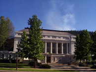
| Looking up toward Gansner Divide from downtown Quincy. Plumas County courthouse in foreground. |
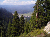
Looking north to Quincy
from Watershed Road(Project Map). |
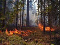
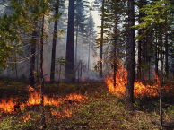
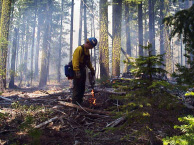
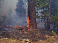
GASNER DIVIDE UNDERBURN
Mount Hough Ranger
District
Plumas National Forest
|
|
| Looking up toward Gansner Divide from downtown Quincy. Plumas County courthouse in foreground. |
Looking north to Quincy
from Watershed Road(Project Map). |
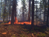
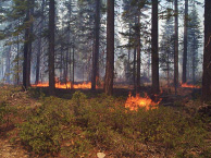
The Mount Hough Ranger District undertook a prescribed fire beginning June 18 and ending June 27. The area of the burn covered approximately 287 acres. The area had been thinned in 1996 and 1997 as part of the Westside Biomass Project.
Herein is a case study of burn. Elements of the case study include the following:
Prescribed burn plan objectives (source: Forest Service Burn Plan),
Fuels information (source: Forest Service Burn Plan),
Photographs,
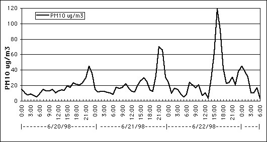
Air quality information,
Other information as it becomes available (post burn fuels information, citizen complaints)
 |
 |
 |
RESOURCE MANAGEMENT OBJECTIVES
A. Reducing fuel loadings to an amount that will not allow for fireline intensities greater than 100, i.e., flame lengths less than 4 feet.
PRESCRIBED BURN OBJECTIVES
DESIRED EFFECTS AND TOLERABLE DEVIATIONS
 |
 |
 |
PROJECT AREA DESCRIPTION:
| Unit No. | 1 | 2 | 3 | 4 | 5 | 9 | 10 | N |
| Acres | 37 | 20 | 6 | 68 | 63 | 42 | 33 | 18 |
| Perimeter | 145 chains | 68 chains | 34 chains | 175 chains | 146 chains | 167 chains | 117 chains | 61 chains |
| Top Elevation | 4,260 | 6,010 | 6,220 | 5,620 | 5,240 | 5,580 | 4,760 | 5,040 |
| Bottom Elevation | 4,100 | 5,830 | 6,080 | 5,160 | 4,720 | 5,240 | 4,340 | 4,480 |
| Aspect | All | N | N | NE | N-W | NE-NW | All | W-NW |
| Slope, Ave% | 15% | 13% | 20% | 15% | 23% | 15% | 10%. | -50% |
| County | Plumas | |||||||
| UNIT NUMBER: | 1 | 2 | 3 | 4 | 5 | 9 | 10 | N |
| NFFL Fuel Model (Inside) | 11 | 8 | 8 | 11 | 11 | 11 | 11 | 11 |
| NFFL Fuel Model (outside) | 9 | 8 | 8 | 8 | 8 | 8 | 9 | 8 |
| FUEL LOADING (TONS PER ACRE) | ||||||||
| 0 -.25" | 0.5 | 1.2 | 1.2 | 0.1 | 0.1 | 0.3 | 0.1 | 1.3 |
| 0.26 -1.0" | 4.4 | 4.1 | 4.1 | 2.3 | 2.3 | 2.1 | 2.3 | 5.8 |
| 1.1-3.0" | 4.0 | 6.6 | 6.6 | 3.0 | 3.0 | 3.5 | 3.0 | 7.8 |
| 3.1-9.0” | 6.1 | 10.6 | 10.6 | 10.9 | 10.9 | 8.9 | 10.9 | 19.1 |
| 9.1-20.0" | 1.4 | - | - | 1.4 | 1.4 | 1.4 | 1.4 | 1.4 |
| 20.1” | 2.1 | 2.1 | 2.1 | 2.1 | 2.1 | 2.1 | 2.1 | 2.1 |
| Total | 18.5 | 24.6 | 24.6 | 19.8 | 19.8 | 18.3 | 19.8 | 37.5 |
Sunday, January ,(, /),( 0(:,(:,( AM